-

by
Joe Lombardi
Weather
New update: Line Of Severe Storms With Drenching Downpours, Damaging Wind Gusts Sweeping Through RegionA cold front advancing from the Great Lakes will move through the Northeast on Tuesday, July 18, igniting isolated thunderstorms, some of which could be severe.The projected timing for storms has shifted, with activity now expected from west to east starting in the early afternoon on ...
-
by
Joe Lombardi
Weather
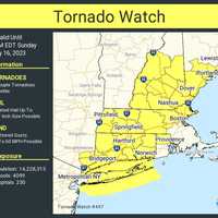
As a slow-moving storm system barrels through the Northeast, a Tornado Watch has now been issued for much of the region until 3 p.m. Sunday, July 16.It includes parts of southeastern New York -- Long Island, as well as Westchester, and Putnam counties -- as well as all eight counties in Connecticut, and the following counties in Massachusetts: Berkshire, Essex, Franklin, Hampden, ...
-
by
Joe Lombardi
Weather
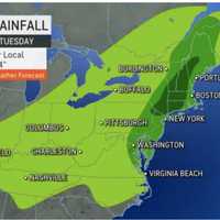
New update: Tornado Watch Issued For Much Of Region, With 60 MPH Wind Gusts, Hail Also PossibleWith much of the region at risk for flash flooding, projected rainfall projections have been released for a slow-moving storm system that has arrived in the Northeast.The system is producing periods of heavy rainfall Sunday, July 16 as it moves from the west to the east.Parts of the region ...
-

by
Cecilia Levine
Weather
The Northeast is in store for another rainy weekend, this time with a possibility of flooding.According to AccuWeather meteorologists and the National Weather Service, severe downpours are posing a threat to the region.Strong to severe storms were expected across the region Friday, afternoon, July 14, and continue over the course of the weekend, the National Weather Service says.Showers ...
-

by
Joe Lombardi
Weather
New rounds of storms with localized downpours and risks of flash flooding are taking aim at the region.The time frame for the first system is Thursday night, July 13 into Friday, July 14 with the approach of a frontal system, according to the National Weather Service.Rainfall of about 1 inch with locally higher amounts of around 2 inches is possible."The strongest thunderstorms during ...
-

by
Joe Lombardi
Weather
A powerful storm system with heavy downpours is moving through the Northeast with significant flash flooding possible in much of the region.A radar view, in the first image above, shows the front edge of the system, sparked by a slow-moving cold front, at about 1:45 p.m. Sunday, July 9. Areas with severe storms are marked in red.Between 2 and 4 inches of rainfall is expected in areas ...
-

by
Joe Lombardi
Weather
A powerful storm system will bring heavy downpours and dump several inches of rainfall throughout the region, resulting in areas of flooding.The system, sparked by a slow-moving cold front, is on track for Sunday afternoon, July 9 into Sunday evening, according to the National Weather Service.Between 2 and 4 inches of rainfall is expected in areas shown in green in the first image above ...
-

by
Cecilia Levine
Weather
July is supposed to be hot. But this? It's abnormally hot.Parts of the Northeast are experiencing the first heatwave of the year this week, with real-feel temps at 90 or above three days in a row, according to AccuWeather. That could be the case in Philadelphia, where temps hit 90 on Monday, July 3, and then 88 on Tuesday, July 4. In Washington DC, temps hit 92 and 93 degrees."Because ...
-

by
Joe Lombardi
Weather
The July 4th weekend has arrived, but chances are the smell of smoke outside isn't coming from barbeques.That's because smoke from Canadian wildfires continues its eastward movement, with poor air quality now affecting nearly the entire region and most of the Northeast.In the first image above, areas in orange are projected to have unhealthy air, and areas in yellow have moderate air on ...
-
by
Cecilia Levine
Weather
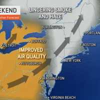
A weekend storm could slightly help improve the Canadian wildfire smoke still lingering along the East Coast, meteorologists are saying.While skies will be sunny with a high in the mid-80s on Friday, June 30, they'll also be hazy for most of the day, according to the National Weather Service.The Air Quality Index remained in the triple digits along East Coast of 9:15 a.m., with code red ...
-

by
Joe Lombardi
Weather
Check conditions for Saturday, July 1, and the updated day-by-day forecast through July 4th here.As smoke from Canadian wildfires moves eastward, poor air quality is now affecting nearly the entire region and most of the Northeast.In the first image above, areas in red are projected to have very unhealthy air quality, orange unhealthy, and yellow moderate on Friday, June 30, which will ...
-

by
Cecilia Levine
Weather
Can't tell if it's smoke or cloudy skies above? The following realtime configurations and air quality maps won't have you guessing anymore.A realtime configuration from Fire Smoke Canada — the Canadian portal for information about wildland fire weather and smoke — shows exactly where each of the more than 150 wildfires are raging and predicts roughly how heavy the smoke will be and ...


